
The Kingdom of Saudi Arabia has developed and implemented a comprehensive addressing system to support the strategic plan for transitioning to e-government services. The National Address is a standardized address system developed by the Saudi Post Corporation (SPL) to provide a unified national address for all regions, cities, villages, and areas across the Kingdom.
The National Address system was created according to well-defined technical and standardized specifications using Geographic Information Systems (GIS) as the primary reference. It covers the entire Kingdom with pinpoint accuracy—up to one square meter—making it possible to locate residential and commercial buildings precisely.
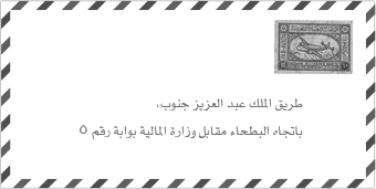
How to write the address in the past

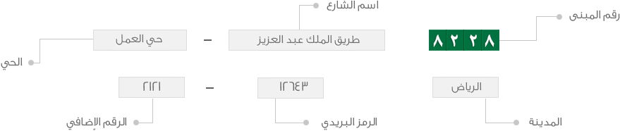
Current method of writing the title
Why Was the National Address System Developed?
The system was developed to transform from traditional descriptive addresses (such as "near the mosque" or "behind the shopping center") to standardized digital addresses that can be used reliably for:
Mail and parcel delivery
E-commerce and online shopping
Government services and transactions
Banking and commercial services
Emergency response services
Urban planning and development
What Are the Components of the National Address?
The National Address consists of seven main parts:
Building Number (4 digits)
Street Name
District Name
City Name
Postal Code (5 digits)
Secondary Number (4 digits)
Unit Number (where applicable)
What is the Building Number?
It is a unique number that represents a residential or commercial building within a postal code. It consists of four digits and serves as a key identifier for your location.
Where is the Main Entrance to the Building Located?
The street name indicates the name of the street where the main entrance to the building or shop is located. This helps delivery personnel identify the correct access point.
What is the Name of the District?
The district name refers to the neighborhood in which the building is located, providing additional geographic context within the city.
Where is the Address Located?
The city name indicates the municipality or urban area where the address is located, such as Riyadh, Jeddah, Dammam, or Makkah.
How Does the Postal Code Cover a Defined Geographic Area?
The postal code consists of five numerical digits, each with a specific meaning related to location. The postal code covers a defined geographic area, such as a neighborhood or residential community. There are currently more than 37,000 postal codes throughout the Kingdom.
What is the Secondary Number?
The secondary number is similar to the building number and also consists of four digits. It represents accurate location coordinates and is extremely beneficial when there are no clearly defined street or district names, particularly in newly developed or remote areas.
How Are Units Within Buildings Numbered?
Each building within postal codes is given two numbers: the building number and the secondary number. There is also a unit number, which identifies specific addresses within a multi-unit building.
Units within buildings are numbered sequentially (1, 2, 3, ...). If a building has no separate units, the unit number is typically considered to be (1). This unit numbering system is commonly used in residential complexes, apartment buildings, commercial offices, and similar properties.
What is the Short Address?
The Short Address is a simplified version of the full National Address designed to make addresses easier to remember and share. It consists of 4 letters and 4 numbers (for example: RAGI2929).
How Does the Short Address Work?
The Short Address is composed of:
First letter: Region Code
Second letter: Branch Code
Third letter: Division Code
Fourth letter: Unique identifier
4 Numbers: These represent the Building Number
Example of a Complete National Address with Short Address:
Short Address: RAGI2929
Full Address: Building 2929 Rayhanah Bint Zaid Street Al Arid District Riyadh 13337 Secondary No. 8118
The Short Address (RAGI2929) provides the same location accuracy as the full address but in an easy-to-remember format. You can use either format when receiving deliveries or filling out forms, though starting January 1, 2026, delivery companies require one of these formats to accept your shipment.
How to Register Your National Address
Registration is free for individuals and can be completed through multiple platforms. You must register before January 1, 2026 to continue receiving deliveries.
Registration Platforms:
You can register your National Address through any of these official platforms:
Saudi Post (SPL) Website – Register directly through Saudi Post
Absher Platform – Under "General Services" → "National Address Service"
Tawakkalna App – Access "National Address" from the Dashboard
Sehhaty Platform – Register through the healthcare services portal
Basic Registration Steps:
Log in to your chosen platform using your National ID (for citizens) or Iqama number (for residents)
Navigate to the National Address registration section
Use the interactive map to pinpoint your building location (or allow GPS auto-detection)
Confirm your building number and address details
Submit your registration
You will receive confirmation via SMS and email
Your address will be activated within 24 hours
Required Information:
National ID or Iqama number
Mobile phone number
Email address
Building location (selected from map)
Accommodation type (residential/commercial)
Once registered, you can download or print your National Address Certificate, which serves as official proof of your residential address for government, banking, and commercial transactions.
For detailed registration instructions, visit the Saudi Post FAQ page.
Understanding the Postal Code Structure
The postal code system is built on established technical principles that divide the Kingdom into hierarchical geographic zones. Understanding this structure helps explain why your postal code is what it is.
How Are the Five Digits Divided According to Established Principles?
The postal code consists of five digits that represent a specific geographical location within the Kingdom. The five digits are divided according to established principles for constructing postal codes, with each digit position having a specific meaning.
What Does the First Digit Represent?
Postal Region Number | Coverage Area |
|---|---|
1 | Riyadh |
2 | Makkah |
3 | Eastern Province |
4 | Madinah and Tabuk |
5 | Qassim and Hail |
6 | Asir, Najran, and Al-Baha |
7 | Northern Borders and Al-Jawf |
8 | Jazan |
What Does the Second Digit Represent?
The second digit represents the postal sector number within each region. Each postal region was divided into postal sectors, with each region containing a maximum of 8 sectors. These sectors are numbered from (2) to (9)—the number (1) was excluded and reserved for government uses or exceptional services that may arise in the future.
What Criteria Were Used to Divide the Sectors?
The sectors were divided according to the following criteria:
The district center (usually the regional capital) is given the first available sector number
Sectors located south of the district center are numbered with even numbers
Sectors located north of the district center are numbered with odd numbers
What Was Taken into Consideration When Dividing the Sectors?
When dividing the sectors, the following factors were considered:
Boundaries of the administrative regions and governorates
Natural and geographical factors, such as mountains, plains, and valleys between governorates
The economic costs associated with providing postal services such as distribution and delivery
Population distribution and population density of sectors
A map showing the postal sectors in Riyadh
What Does the Third Digit Represent?
The third digit represents the postal branch number within each sector. Each postal sector was divided into several postal branches, with a maximum of eight branches per sector. Branch number (1) was reserved for government use or exceptional services.
The branches were positioned so that, whenever possible, their boundaries were along main roads or streets for ease of navigation and delivery.
How Were Postal Branches Numbered in Different Types of Cities?
The numbering system varies based on the city's geographic characteristics:
How Are Inland Cities Numbered?
These are cities that do not overlook the coast, such as Riyadh, Buraidah, and Hail.
A key focal point (pivot point) is identified for each sector
Branches located west of the pivot point are given odd numbers (3, 5, 7, 9), ascending in order as you move further west
Branches located east of the pivot point are given even numbers (2, 4, 6, 8), ascending in order as you move further east
How Are Coastal Cities Numbered?
These are coastal cities that grow along the coast, such as Jeddah and Yanbu.
A key focal point is identified for each sector
The division is based on the city's location on the coast and the direction of its urban expansion
Numbering follows patterns appropriate to the coastal development
How Are Cities That Grow Unevenly Along the Coast Numbered?
These are coastal cities that grow unevenly along the coast, such as Dammam and Khobar.
A key focal point is identified for each sector
The division is based on the city's location on the coast and the direction of its urban expansion
Even-numbered branches are typically assigned to areas closest to the coast
What Does the Fourth Digit Represent?
The fourth digit represents the postal section number within each branch. Postal branches were divided into several sections, with a maximum of nine sections per branch.
How Are Sections Within the Branch Distributed?
The sections within each branch are distributed based on main roads and streets, grouped according to street classifications. Postal sections are numbered based on their proximity to the sector axis:
Smaller numbers are assigned to sections closest to the axis lines
Numbers increase progressively as sections are located further away from the axis
A map showing the postal sections in Branch 2 of Sector 2 of the Riyadh region
What Does the Fifth Digit Represent?
The fifth digit represents the postal square number within each section. Each postal section is divided into several squares of varying dimensions.
How Is Each Postal Section Divided into Squares?
The division of sections into squares follows these principles:
The final area of each square should not exceed 4×4 km²
Squares within urban areas are typically approximately 2×2 km²
Squares in densely populated urban areas are approximately 1×1 km²
How Are Squares Numbered?
The division of squares is based on the main and secondary road and street network. Numbering follows proximity to the branch axis:
The smallest number is given to squares closest to the axis
Numbers increase progressively as squares are located further away from the axis
This systematic approach ensures that every location in the Kingdom has a unique, logically organized postal code that reflects its geographic position within the national grid.
Additional Services and Features
What is the Alami Service?
Through the National Address system, Saudi Post offers the Alami service, which allows you to register up to 10 international addresses in different countries. These international addresses are linked to your Saudi National Address, making it easier to shop from international online stores and have items shipped to Saudi Arabia.
What is the AWFAR Service?
AWFAR is a home delivery service that brings your P.O. Box mail directly to your registered National Address. If you subscribe to AWFAR, letters, parcels, and documents from your P.O. Box are forwarded to your home, eliminating the need to visit the post office.
Can Businesses Use the National Address?
Yes, all businesses operating in the Kingdom are required to register a National Address. Business registration enables:
Electronic transactions with government ministries (Interior, Labor, Commerce)
Official mail and document delivery
Commercial shipping and logistics operations
Compliance with regulatory requirements
Business registration may involve fees depending on the type and size of the organization. For more information, visit the National Address for Business page.
Benefits of the National Address System
The National Address system provides numerous advantages:
Accurate Deliveries: Eliminates delivery delays and missed shipments
Reduced Communication: Fewer phone calls from delivery personnel asking for directions
Government Services: Required for accessing e-government services, banking, and official transactions
Emergency Response: Enables faster response times for emergency services
E-Commerce Growth: Supports the expansion of online shopping and digital commerce
International Recognition: Accredited by the Universal Postal Union (UPU) and ISO standards
Mandatory From January 1, 2026
Starting January 1, 2026, all parcel delivery companies in Saudi Arabia are required to refuse shipments that do not include a valid National Address. This means that if you have not registered your National Address, you will not be able to receive parcels, online shopping deliveries, or postal shipments. Register your address now through Saudi Post (SPL), Absher, Tawakkalna, or Sehhaty platforms.
Remember: Starting January 1, 2026, your registered National Address is mandatory for all deliveries. Register now to avoid service disruptions.
For more information and to register your National Address, visit Saudi Post (SPL) or contact customer service at 19992.
Saudi Arabia Address Generator
Looking for Saudi Arabian addresses? Generate addresses following the National Address format.


